Witnessing the Birth of a Climate Solution

002_4540-lg

The public, yet somehow photo-banned, turnout facing the PacifiCorp Huntington Power Plant, along Utah Highway 31.

In one 24 hour period in May 2016, across two western states and over 650 miles, I saw three coal-fired power plants, one hydroelectric dam, a massive new solar farm project, and a unique solar plane called the Solar Impulse 2 that was on its way to completing a ’round-the-world trip without fuel for the first time in human history.  And I was driving an extended range electric vehicle, or EREV, the Chevy Volt. Now that’s a whirlwind energy tourism tour.

Granted, I wasn’t stopping to charge my EREV every EPA battery capacity rated 38 miles, but relying on the “extended range” technology that allows gasoline to generate electricity for the batteries.  Driving an electric vehicle across the country is comfortable and fun in a Volt, though I’m hopeful for the day when I’ll be fast-charging instead of refueling the battery.  But whereas some people use the Volt for 100% electric miles and only locally as a commuter car, I use the full design of the vehicle, and drive thousands of miles on single trips, as well as my local daily commute.

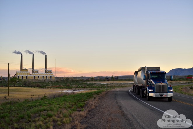
I began my day at sunrise at the Huntington coal-fired power plant, near Huntington, Utah, where I was visited by security who was curious about my photography.  This was a marked difference in behavior for security of the power plant, which had been attempting to stop me the previous day from photographing their properties.  Having left all that needless drama behind, I was making my way southwest to reach the Red Hills Renewables Park, near Parowan, UT, which made me feel much more optimistic for my day.

But before reaching my destination, and while stopping for one of those gas station breaks where I needed the food and facilities more than my high mpg car needed the fuel, I checked my email and noticed that one was from the Solar Impulse 2 team, notifying me via broadcast newsletter that they were launching for their next leg from Phoenix, AZ that night!

I calculated my luck, my odds of reaching it in time, and my plans for the day.  Could I drive over 500 miles and still hit my two pre-planned cross-country photo-targets I wanted?  In under 13 hours?  Google maps revealed it was a 10 hour drive.  “Well hell… that gives me three hours of ‘play’ time,” I remember thinking.  I’d have to drive without a wink of sleep, and arrive in the middle of the night, but I’ve put myself through worse driving conditions before.  And it’s a once-in-a-lifetime chance to see a history-making event… why not go?!  I definitely felt that I would regret not at least making the effort.  I decided to do the full whirlwind tour: photograph a sea of mid-day solar panels in Parowan, then scream down southeast to Page, AZ to photograph the highly polluting Navajo Generating Station, as well as Lake Powell and Glen Canyon Dam if I could get there before dark, then bee-line it straight south to the Goodyear Airport in Phoenix to see the Solar Impulse 2.

I was worried I would drive the entire way there, be turned away at the entrance and not get to see the plane take off, so I contacted their media team via email.  Through a back-and-forth over email, I wasn’t given any assurance that I’d be given the required RSVP credentials to enter.  What the hell… go anyway, I told myself.  Once-in-a-lifetime, I told myself.  600 miles and 13 hours of driving and photography to go… sounds like an adventure!

002_4547

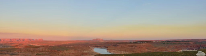
Red Hills Renewable Energy Park, Parowan, UT, looking north, just a small portion of the entire 630 acres array.

First stop: at Little Salt Lake, near Parowan, UT, there is a 104 MW photovoltaic (PV) solar array called the Red Hills Renewable Energy Park, owned by Scatec Solar and just six months old, having been completed in December, 2015.  To that point, it was the largest solar panel array I’d seen.  Very impressive at over 600 acres!  I was wishing that I had a drone camera to capture this massive spread across a portion of this valley, but lacking such, decided that the nearby rising hillside might provide a similar effect at a distance.  After abandoning my position fence-side and climbing onto the sides of my car to photograph the array without the fence in my frame, I gained some elevation south of the Park and was again impressed with this project’s size.  Certain lenses, even at this distance, couldn’t capture its breadth!

002_4618

Dr. Frankenstein’s backyard. A vision of 104 MW of electrons funneled from 340,000 solar panels across 630 acres through these wires at the Red Hills Renewable Energy Park, supplying energy for 18,500 households.

I also noticed it had it’s own substation that tied into one of the three cross-continental transmission lines skirting the project’s western edge.  Some of this infrastructure makes for interesting shapes and subjects to photograph.  One piece of the substation looks like a 1950’s vision of futuristic technology as a round sphere with spikes of wires exiting in different directions.  I have no idea what its function is, but it looks big, powerful, and cool.  And dangerous.

Okay… without property access and nobody immediately available to ask, plus a deadline, I decided to scoot (“shoot and scoot” being the theme for this day).  Hitting the road for Page without the ability to stop at a photographer’s whim was kind of painful with all kinds of mountain, canyon, and valley scenery flying-by.  But the payoff was on the approach to Page, across the red rock and desert valley, as the western sun began receding through the layers of Navajo Generating Station smog… everything was turning red… and the red rocks really start glowing when bathed in red light, and I was drenched in photographer’s golden hour awe bliss.

002_4661

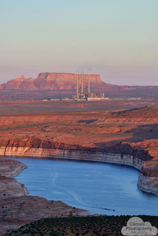
The Navajo Generating Station (Salt River Project), near Page, UT. This 2,250 MW power plant provides power across the west, including making water run uphill through the Central Arizona Project. This plant is the single-largest emitter of carbon dioxide in America and currently permitted to run through 2044. Lake Powell, in the foreground, allows flatwater recreation and adds more power through the 1,320 MW Glen Canyon Dam.

But I didn’t have time to scout my locations, prioritize shots, or anything!  Thinking fast, I decided this would have to be a swoop-through shoot.  Stop at a distance on approach for the grand scene… shoot… scoot… get closer for a mid-valley scene at a tourist trap of a rest stop with an elevated view of Lake Powell with the power station in the distance… super-telephoto to pull in that plant in the distance with the water in the foreground, and soaked in red rocks and red sunset at its height… quick lens change for wide-angle to grab the entire scene, and all that wafting smog… scoot… drive to the Glen Canyon Dam… quickly determine I want several angles of shots, and do a couple of shoots on both sides of the bridge as the sunset waned… scoot… no time to drive closer to the power plant… gotta close the gap between Page and Phoenix through the dark… damn… can’t see the gorgeous red rocks along the way on this trip.  The glorious Navajo landscape fades, and I’m left imagining what I’m passing from prior trip memories.

002_4668

Dam blocking the river (rt), reservoir generating methane from decomposition (center, bottom), coal-fired Navajo Generating Station (center) polluting the visible sky with multiple emissions including carbon dioxide in massive amounts, coloring the sky with a technicolor sunset among red rock cliffs and a sagebrush sea. Hauntingly beautiful.  This is a similar vision to “The Scream.”

Stopping in Flagstaff for some much needed food and a break was refreshing.  I needed that, because I was really beginning to feel the miles, the darkness, and my sagging eyelids.  …on the road again… desirous of stopping at certain places for some spectacular astrophotography… damn… next time… fight the head-nodding sleep enemy with some boisterous loud music and road food… but I was also energized for what I was about to witness in a few hours.

I arrived in Phoenix somewhere between midnight and 1 am, and I managed to identify where the party was held at the airport.  I began seeing local T.V. news satellite trucks and people converging on one building as I approached, and upon entering, there was someone checking for tickets haphazardly as people flowed in without lines or order… I said I didn’t have one, and he let me through anyway… whew… glad I took the chance!

The plane was out of the hangar and on full display with the pilot, Bertrand Piccard, in the pilot’s seat already.  I discovered by talking with a few people in the crowd that the speeches were already done (damn, missed that), and they were prepping for take-off.  But I still had a two-hour wait for that to happen.  At this point, I was a bit delirious from so much driving and an early morning rise, but the energy of the crowd and the alertness of the seemingly dozens of workers kept me wakeful.

In hindsight, I wasn’t at the top of my game with regard to making great images in tough photographic conditions: artificial bronze-colored light at night with variable speeds of motion from people and the plane… widest aperture!… increase shutter speed!… who cares about white balance-figure that out later in post!… maximum ISO!… better to have higher noise than to make a bad shot with motion-blur!… test shot… adjust… test shot… my brain was shouting orders to my fingers that didn’t want to follow through with the camera in all cases because several of my shots, upon later inspection, aren’t to my usual exacting standards, and for the flight itself, there was no re-do, meaning planning ahead was necessary while waiting for go-time.  I decided to start with the 50mm for the runway shots during take-off, then switch to the 200-500mm for lofty distance shots.  And, at 3 am, after being awake and driving over 650 miles over 20+ waking hours, I think I even had trouble with making sure I was getting a decent focus.  Or maybe my bleary eyes thought it was focused when later they didn’t all come out as great as I normally want.

So I was a bit disappointed with my photographic results, but I was definitely thrilled with simply having made it there in one piece and not having driven off the road somewhere along the way.  I was witnessing history in the making.

Then, when you would have expected the crowd to shout cheers and a raucous calamity of celebration when the plane lifted off the runway, still at a distance not too short from the starting point, we were all silently transfixed!  Nobody had ever seen such a thing before!  It had the speed of a Wright Brother’s plane!  Incredible.

(Click on images above for full captions and large size view.  Note that these are low-res images, which degrades the image quality.  For higher-resolution images, see www.climatephotography.com.)

The experience of getting to see this experimental plane, lifting off the runway like a breath-lifted feather in the light desert warm air, silently gliding, almost hovering overhead, with a comparatively wide 747 anchored on the runway underneath, I was amazed at this feat.  This plane, carrying a single pilot, with a massively wide wingspan and seemingly heavy by the way multiple people man-handled it while manually taxiing down the runway, was simply floating aloft up there, making slow, wide circles to gain altitude before meandering eastward into the darkness.

Andre Borschberg states “To build an airplane of the size of a 747 with the weight of a car, something which was considered impossible by the aviation industry, we had to develop the right mindset in order to push the limits of the technologies.”  That includes, by the way, propulsion power equivalent to a couple of blow dryers to circumnavigate the globe.  If this is starting to sound a bit like that MacGuyver episode where he built a plane out of bamboo and garbage bags, you wouldn’t be far off from the creativity of these guys.  However, imagine MacGuyver with a massive budget, and access to the entire planet’s best technology to create this plane.

Fully charged, this plane’s batteries stored enough energy to fly at night, making enough room for the electrons to be refilled by the solar cells spread across the back of the massive, slender wings to refill by the next nightfall.  The propellers were very quiet.  In fact, I couldn’t even hear them beating the air.  That must have meant a low-friction, high efficiency.  What I did hear was what you might expect from an electric vehicle… you can even hear it faintly in my EREV/Volt… a faint electric whir.  Unmistakable, I heard it overhead.

This is history I’m witnessing, I thought at the time.  And it was.  A convergence of multiple clean, lightweight technologies and the spirit of human adventure of these two pilots, Bertrand Piccard, flying overhead, and Andre Borschberg, sharing the flying load in back-to-back legs across this planet of ours.  What does the future hold, I wondered?  Will we all be flying in battery-charged, solar planes someday?

This is history in the making in another way… the birth of a climate solution.  What scale in aviation might these technologies achieve?  Next, we’ll see solar unmanned drones by Facebook beaming WiFi to entire continents while staying aloft for months at a time, already in test flights.  Or Airbus’ Zephyr drones.  Or Google’s balloons.  I look forward to the Solar Impulse team’s future projects, already being planned.

This exhibition had completely enchanted the crowd of a couple hundred admirers, from children accompanied by parents, to paparazzi, to grandparents in wheelchairs.   We were all mesmerized at the graceful and vaguely manta ray-esque front profile of this flying wonder’s departure.  Its etherealness was enhanced by the backdrop of a star-studded night sky, twinkling up there, seemingly beckoning this quiet solar wing of humanity’s Icarusian whim and audaciousness.  But whereas Icarus’ wing wax melted and weakened from the sun, the Solar Impulse 2 wings soak in the warm photons and are strengthened.

That flight would end over 18 hours later, as planned, in Tulsa, OK.  Later, the round-the-world journey would end in Abu Dhabi, UAE, on July 26, 2016.

How far we’ve come, from digging out rocks and burning them for heat, to capturing electrons from the sky, and using them to fly.  And yet, I had just witnessed, in a single day, our guarded grip of a trusted and faithful coal-fired legacy, only to be amazed at the birth of new and innovative applications of existing technology.  The #futureisclean.

To view all related galleries for this whirlwind energy technology tour, see the Western States Energy Infrastructure set of galleries at Climate Photography.  Prints and downloads are available.

Photography “Not Allowed” at this Utah Scenic Turnout

002_4343

Carbon County seal. Carbon County is home to the Castle Gates Power Plant, also known as the Carbon Plant, which has been shut down by its owners, with the decommissioning currently ongoing.

Security in America has become a worrisome national pastime to the point of being the butt of many a joke.  So it may not come as a surprise, but there’s a place in Utah where you may actually be harassed by security if you are taking pictures at a roadside-advertised “Scenic Turnout 1/4 Mile” ahead turnout.  And when you get there, security may tell you that your picture-taking is “against company policy,” tell you that they’re concerned that you’re a terrorist (not assuming you’re a tourist), and/or that pointing your camera in certain directions has raised “internal alarms all the way up to the Vice-President.”  I was told all of these things… and I was standing on public land along Utah Highway 31 in Huntington Canyon.

Okay, enough with burying the lede… at this location in Huntington Canyon is the PacifiCorp Huntington Plant, a coal-fired power plant, and the overzealous security bleeding into the public streets are employed by none other than billionaire Warren Buffett, as a subsidiary of Birkshire Hathaway Energy.  Someone should inform Mr. Buffett’s security that there are already more than a few photos of his power plant already online.

Tourist terrorists?

This canyon, in fact, is on the Visit Utah (the very official Utah Office of Tourism, which is itself an office within the Governor’s Office of Economic Development) website map as an attraction for climbing and bouldering.  I guess photography is verboten?  Maybe it’s a given?  It’s Utah!  The ridiculousness of banning photography from the public highway next to the Huntington Plant is most clearly understood when you realize that the State of Utah actively advertises the highway I was photographing along as an official Utah Scenic Byway, and that this one is called “The Energy Loop: Huntington/Eccles National Scenic Byway.”  You read that right… The Energy Loop.

You will see signs for this “Energy Byway” along the road, too.  But no warnings that you may be considered a terrorist for pointing your camera at any energy infrastructure, with security coming out and driving a half-mile down the road to tell you to put your camera away, while they ask your name, write down your license plate number and converse with a centralized dispatch over handheld radios (this really happened).  It would seem that energy pride has given way to energy shame in Emery County where these plants are located.  Or energy protectionism.

If you’re the type of person or family who wants to tour America’s energy infrastructure, and you seek out scenic byways on long road trips like the one in Utah called “The Energy Loop,” you might be in for a surprise when you or little Tommy or Jane pick up a camera to photograph it.  In fact, in my tour of America’s energy infrastructure across 11 western states this past May and June, there were zero fossil fuel-fired power plants that didn’t have security present who either spoke about or harassed me for the topic of terrorism, and stating emphatically that photography is not allowed or against company policy, and I needed to leave that instant.

Gee, it almost seems like they’re trying to hide something.

You have to admit, though, that the coal industry has been running the gauntlet of regulation restrictions, lawsuits, and a dwindlingly favorable economy that is causing bankruptcies en masse.  Terrorism, in fact, is the least of their problems, unless there’s classified intelligence revealing otherwise that isn’t public knowledge, and Joe and Jill Public are presumed guilty before proven innocent by security who can’t differentiate who is whom and prefer to start conversations with allusions and accusations.  “They” might be feeling a little defensive.

002_4468

Hundreds of coal-truck deliveries like this one are made each day to PacifiCorp’s Hunter Power Plant, near Castle Dale, Utah. This image shows an empty coal-truck returning to the East Carbon mine over 60 miles to the northeast, the coal drop zone mid-frame in the background, the Hunter Plant on the left, and a local electricity power line running through the frame left to right.

Sierra Club named enemy #1

Perhaps that is why, when I visited the Hunter Power Plant, another coal-fired station just 21 miles to the southeast, near Castle Dale, I was asked by security there (in addition to all of the above security questions I also heard at the Huntington Plant) why I was taking photos.  Why would a front-line security guard be asking someone stopping by the highway why they were taking photos?  I asked the security guard.  Not quite tight-lipped, she said that Sierra Club had recently been around taking photographs of their operations, and that there was a lawsuit between them.

“You don’t work for Sierra Club, do you?”  She asked over her shoulder as she was walking back to her truck.

“No, I do not work for Sierra Club,” I replied, truthfully stating fact, because my employment with Sierra Club had ended about a year earlier.  Her response was a giggle as she got in her truck and watched me leave.

Sierra Club has one of the most successful environmental campaigns that causes courts to enforce environmental regulations on coal operations, and heavily influences companies and investors in these companies to shut them down.  In fact, only a few hours before visiting both the Hunter and Huntington plants (in that order), I had also visited a power station that was in the process of being shut down altogether, just 45 miles to the north.  Just the mere threat of stricter air quality regulations forced their owners to decide to shut down.

Carbon’s self-implosion
002_4358

The decommissioned Castle Gate/Carbon Power Plant is backed by a cliff, boxed-in by a highway wrapping around two sides, and on the fourth side is layered by a dirt road that leads to the coal mine and ash landfill, railroad, river, and another major highway. Aside from limited space, security was a major problem for this doomed power plant.

The Castle Gate Power Plant, or Carbon Plant, is located between a rock and a hard place.  Literally!  The plant was built in an era that simply burned coal to generate electricity.  Emissions controls were such that relatively little space was required.  When you stand outside the Carbon Plant, you’ll wonder why its location was chosen- it was built into the base of a cliff, with a highway wrapping around two sides (with Willow creek on the other side), and only enough space on the remaining side for a dirt road to pass between it and the Price River.  Somehow, amazingly, a railroad is also shoehorned into that latter strip of land.  And on the other side of the Price River is a major highway connecting central and southern Utah to Salt Lake City to the north.

The Carbon Plant’s “rock” is that cliff.  The “hard place” is not only the increasing concern over security because of its proximity of shared land with two highways and a railroad, but also because of new clean air rules that would require it to upgrade its emissions control technology for what are called the “Mercury and Air Toxics Standards,” or “MATS.” That MATS technology would have required an expansion in space to accommodate technology that would have reduced pollution that Hunter and Huntington plants are currently being sued by Sierra Club about- pollution that reduces visibility in national parks and causes harm to humans (among other species).

I happened to be photographing the Carbon Plant when a woman leaving the facility (a door just steps away from her vehicle across the highway) made eye contact with me.  I asked her, naively, why the plant seemed to not be up and running?  She took a look at my parked Chevy Volt, which has Colorado’s new “Protect Our Rivers” license plates, and said, “looking at your license plate, I don’t think I should say anything.”  She said she “knows Sierra Club is in the area.”  Surprisingly, she didn’t say a thing about the  camera hanging from my neck.

This is an industry that has “had it” with environmentalists- or at least a company, since the Carbon Plant is also owned by PacifiCorp/Birkshire/Buffett.  And this woman was one question away from venting.  I asked again: why is the plant shut down?  She said, “environmentalists!”  With an increasingly winded voice, and an ever-brightening red face, I determined to listen more than converse, and simply let the venting flow out…

Paraphrasing the flurry of information she provided, she said that the plant could not remain open because the owners decided to shut it down, and that they only did this because of the impending MATS requirements.  But she seemed livid about this point: apparently nobody even tested how the plant’s emissions could or could not meet the MATS requirements!  So, basically, how dare they shut the plant down without even testing.  For her, this plant was life itself.  The plant employed over 700 people, she said, when it was in operation, and now, solely for the purpose of decommissioning the plant, there are only three.

That was to say nothing of the nearby mining operations that were active with vehicles navigating winding mine roads visible from the highway just a mile away down-river.  Or the dozen or more construction workers monkeying around all the levels of the plant… I asked what they were doing up there.  She said they were doing the asbestos abatement as part of the decommissioning.  Nice.

So, because the location couldn’t fit the “scrubbers” (pollution control technology, which can in itself create a water-mixed toxic sludge of pollution that must be managed, switching dispersed air pollution for potential point-source ground and water pollution), the plant had to be shut down, and the company decided to do this on its own.

She apologized for unloading on me. She asked,”do you know what this does to a community?”  The venting was over, and we moved into acceptance mode when she entered her car saying that she was retiring, “after this… I’ve had it.”  And she drove off.

What does this do to a community… it’s a good question.  If she and I were in a different setting, I would have liked to have discussed that topic with her.  It’s the crux of the argument on both sides of the debate, amazingly enough.

On the industry’s side, which she was attempting to defend, it’s all about jobs and economy of the community.  Perhaps also cultural pride going back generations (more on that below).  And on “the environmentalists” side, uhh… it’s about the environment the community lives in… the air that community breathes, the water that community drinks, the safety issues that community faces from industrial activities, and the climate threats that impact that community and the entire planet.  Everyone, it seems, is arguing for providing for healthy, happy families, to put it simply.

Star-spangled banning

That’s why, later that night, when I was faced with a night security guard a half-mile down the highway from the Huntington Power Plant, who was told by his dispatch (I heard) to “try to hold him there,” because they were sending someone out, I had already learned that this company’s staff was on the edge- I was not sticking around to get berated again.  I said, “I have what I came for… and I’m leaving.”  I left the security guard in the darkening dusk in my rear-view mirror.  I went a short way up the road and pulled off into a campground, decided I wanted a shot of the moon between the smoke stacks, and waited for the exact window of time it would be there (thanks to a photography app, I learned I had a relatively short wait).

Coal Industry in Carbon and Emery Counties, UT

My security-scrutinized, photo-policy-busting image that sent off internal alarms all the way up to the Vice-President and ferreted out a night shift supervisor to track me down in person. This image was made from the side of the Utah Energy Loop scenic byway… public land.

The time came.  I felt a bit naked without the necessary black clothes, gloves, and face camouflage one would wear during a night raid while avoiding security.  But then the reality of the situation began sinking in, when I realized that PacifiCorp had made me feel like I was a criminal for making photographs while standing on public land.  They don’t realize that actions like theirs cause people in the public like me to challenge them when they overreach.  Like Sierra Club’s lawsuit.

I set up my camera, got the long exposure image I envisioned, and in that time, security again came slowly down the road, actually passing without stopping or harassing me this time, and continued driving.  I knew what was going on… whomever they were trying to send out to speak with me before, I had just been flagged again, and they didn’t want to scare me off by harassing me.  Again.  I left, passing the security guard in his truck parked around the next bend.

It was getting late that night, and I hadn’t really had anything decent to eat, so I drove to the nearby City of Huntington, a small town that only had an open gas station to choose from for my dinner options.  While selecting from my delectable menu, I noticed a big, white truck pull up next to my car outside.  Hmm… white vehicles are a dead givaway for security and fleet vehicles.

About to enter my car and drive off, the driver of the truck who also had purchased a candy bar in the store started up a conversation with me, telling me his name and that he was a night shift supervisor. He had guessed where I would be (small town, one open store), and tracked me here.  We had a real conversation.  The kind of conversation I had wanted to have with the woman at the Carbon Plant, but was berated for having the wrong kind of license plate.  This gentleman, however, was kind, approachable, and level-headed.  And even though he didn’t live in the community in which he worked (he lives out of state, he said), I am glad locals are exposed to his demeanor and openness to have what could otherwise become a divisive conversation.

He and I conversed in that gas station parking lot for about an hour, discussing everything from jobs and economy to climate change and pollution.  I told him that environmentalists don’t begrudge him one bit for conveying his point about providing for his family with a coal job, while he admitted to me that he had no understanding whatsoever of internalizing negative externalities of fossil fuel use, but was glad to have learned.  We educated each other about our perspectives on coal-fired power plants, without any indication of derision, anger, stress, or any pejorative uttered.

002_4388 & 002_4395

Propaganda. Top: A local business slogan, usurping an environmental organization’s name, “Earth First!” Unabashed coal mining pride. Bottom: a billboard a short distance from the upper sign, which reads, “PRODUCING ENERGY = MINERAL LEASE $ = COUNTY PROGRESS. Support our Three Kings,” followed by a “no” symbol slashed over Tax $, meaning “no tax money.” The black image of “Coal, Gas, Oil” production operations sits aside another term borrowed from the environmental movement, “progressive,” it says, “For a complete list of progressive projects, http://www.energy4utah.org.” Both of these signs were posted along the highway just a mile or two down the road from the now-decommissioned Castle Gate/Carbon coal-fired power plant and mine.

This was someone who appeared to have had no agenda and was genuinely curious.  A rare find in an industry painted broadside with propaganda to hide its warts.  The same can be said of environmentalists.  The devil is in the details… is it propaganda if facts are stated emphatically or with market-researched terminology for best acceptance?  I have a feeling that both sides employ that strategy, but no genuine propaganda was present on this night.

This is the kind of conversation that I want to explore.  If the Warren Buffetts of the fossil fuel industry world, and their board members, are at all interested in finding solutions to the environmental problems caused by fossil fuels, then it will take conversations like this man and I had in the parking lot of a City of Huntington gas station.

Perhaps I owe Sierra Club my thanks, because I don’t think I would have been able to have that conversation if my photographic activities that day hadn’t set off “internal alarms all the way up to the Vice-President,” according to this PacifiCorp employee, which sent him searching for me in the night.  He had to answer to that Vice-President about what I was going to do with my photographs.

Well, if that VP happens to read this account of that day, that shift manager deserves a raise (presuming he’s not responsible for the security’s behavior) for his public relations capabilities.  He even offered to take me on a tour of the plant if he could get approvals “up the chain,” I presume, from that VP.  I said I’d be thrilled to tour the plant, see their emissions controls like the “baghouse” he described Warren Buffett installed before it was required in order to reduce particulate matter emissions from 10% to 1%, and others.  I gave him my number and said to give me a call if he gets the approvals by morning, and that I’ll be staying nearby (in that campground situated right next to the plant).

Into obsolescence via evolution into renewables
002_4540

How much more touristy can a road-side attraction get?! There are even interpretive signs that explain how the power plant functions! Yet security expects no photos to be made here… unless you are interrogated first.

The next morning, I woke early, went to the “Scenic Turnout,” and started taking photos.  About a minute later, security showed up, again.  It was the first security guard I met from the Hunter Plant the day before.  This time, there was no aggressiveness, no berating for using my camera, and a lot more curiosity.  I think my point about standing on public property was heard loud and clear, and she probably heard about last night’s chat in town.

She and I talked for a little while, and we tracked over several topics previously discussed the night before with the shift supervisor (though I never did receive that call inviting me to a tour by the approval of the higher-ups).  Predictably at this point, all of her conversational points were about jobs and community.

She even conceded that she understands the coal industry is losing its own jobs due to technology improvements, such as machines now doing the work people used to do in the mines.  Her husband, she said, works in medical technology, and she considers how many jobs those new technologies and her own husband cause to become obsolete, but that she takes solace in knowing there are still jobs in operating that technology.  Sounds like an observation of automobile transportation evolving from horses and carriages with jobs shifting to newer technology.  Like renewable energy jobs evolving from coal, oil, and gas jobs.

Again, I shared my perspective about issues that are important to her community, even if they don’t directly think about climate change, clean air, clean water… and safety.

002_4324

The plaque reads: CARBON COUNTY COAL MINERS’ MEMORIAL WHEN COAL MINING STARTED IN THE BOOKCLIFF AND WASATCH PLATEAU BACK IN THE LATE 1800’S MANY MINERS FROM DIFFERENT ETHNIC GROUPS FROM AMERICA AND COUNTRIES FROM AROUND THE WORLD CAME TO CARBON COUNTY TO MINE THE COAL TO PROVIDE FOR THEIR FAMILIES, HEATING OF THE HOMES, THE MAKING OF STEEL, THE PRODUCTION OF ELECTRICITY, AND OTHER PRODUCTS. THESE MINERS WERE EXPOSED TO COLD, WET HARSH CONDITIONS, BAD TOP AND RIBS, EXPLOSIVE AND POISONOUS GASES, CONFINED CONDITIONS WITH MINING MACHINERY AND COAL DUST. THIS MEMORIAL IS DEDICATED TO ALL MINERS WHO PAID THE ULTIMATE SACRIFICE WITH THEIR LIVES AND TO ALL MINERS WHOSE LIVES WERE SHORTENED BY CRIPPLING INJURIES, NATURAL CAUSES FROM MINING CONDITIONS AND MINERS PNEUMOCONIOSIS.  [End]  There were a dozen or more large plaques that were each triple-listed with the names of the fallen.

Just the day before, I photographed and paid my respects with a moment of silence to the coal miners memorial in Price, located between this power plant and the closed Carbon Plant.  I asked her if she had done so before, reading the plaque underneath the statue of the proud-looking miner.  She had not.  I informed her that the plaque could have been written by an environmentalist, with how visceral it sounded while describing the horrendous conditions and varied horrible maiming and deaths that have been caused by mining, transporting, and burning coal, in these communities.  But it was written, presumably, by the community it was in.

We parted on friendly terms, with her knowing that I held no grudge against her for securing coal-fired power plants.

I mean, who knows, I could have been a terrorist targeting the coal plants instead of aiming a Nikon at them.  What damage could an accident cause?  What harm does a fossil fueled power plant, let alone three within a short distance, invite to their community through terrorism, perceived or real?  What comparative solutions to all of these problems do renewable energy sources provide to communities?

We’re all arguing for the same things, including energy jobs and the need for responsible security; we just may (currently) disagree about the power’s source of energy.

That’s the energy source challenge I look forward to working to answer.


All images shown here, and more, are available for prints and digital license downloads at Climate Photography.

Utah’s “Giant Flowers”

002_3782

Latigo Wind Park near Monticello, Utah. The Latigo Wind Park, owned by sPower, completed construction in December 2015. These mountain-side turbines are monitored very carefully by two contracted biologists, who are networked with the individual tower operations and can slow or stop individual turbines in the Park at any time to prevent an eagle collision. On the day these images were made, contractors had just completed construction of two eagle watch towers for the biologists, who were operating from the grounds for five months, in the elements. These strategically-positioned towers give 360-degree views of the Park, and shelter to the biologists during the roughest winds and weather. Curtailing individual towers for Eagle safety does not significantly impact the operations of the entire project, and is becoming a common practice among wind turbine operators, among other technology uses for avian safety. Photos in this gallery are property released by sPower.

Driving through Monticello, Utah, approaching from the south and eastern flank up the long shoulder of an ancient mountain, Apajo Peak, over the years since the ’90’s when I would explore the San Juan Mountains in southwestern Colorado, Shiprock in northwestern New Mexico, and north to Moab in eastern Utah, I came to get to know the landscape to the point that when you come around a corner, you have certain expectations.

On this trip, not having come through in over a year, my mind was blown away by the practically alien sight of giant white wind turbines in the unlikely location on the ridge line of a Utah (Utah!) mountainside.  After having just spent time photographing some of the most polluting coal mines and power facilities in the West, my mental state soared with the sight of this new, “clean” energy source.  (In reality, wind turbines could be considered one of the least “dirty” energy sources, because no energy source comes without some form of environmental impact- more on that later.  Still, wind turbines are nearly as clean as it gets!)

Wow!  Renewable energy is coming online so fast!  In a seemingly random and rural place like this!  In such a conservative state!  Screw my plans to spend a rest day in Moab, I’m hanging out in Monticello, Utah today!  First stop… find information at the tourist visitor center in town.  Other than as a pit stop, mining information from locals here was not very helpful.  The only person there when I arrived was ambivalent, when asked what she thought of the new turbines.  She said she didn’t care one way or the other.  Okay… and where is the rest room, I asked?

Just before leaving, another worker arrived at the desk, and I thought I would give another local a shot at my question.  “What do you think about the turbines?”  I was asked in reply, as if to gauge whether I was friend or foe before giving a real answer to my question.  Cautious and protective, I remember thinking of this second woman.  She had an opinion.  I proceeded…

“I think they’re great,” I told her.  I was sounding a little like Tony the Tiger.  But with my cheesy answer she confided that she thought they were beautiful, “they look like giant flowers,” she said excitedly!

Looking at the first woman, I could tell that her seemingly nonchalant and slightly prickly answer to my question earlier was, in fact, a learned response to her otherwise disapproving opinion of the turbines.  She was keeping the peace, and knew a negative response in the setting of a town visitor center was not setting the right mood for the town, so she chose to plead the 5th in her own way.

After chatting briefly, and finding out from the first woman that they were out of descriptive brochures about the turbines, I left with a refilled water bottle from their fountain.

Arriving at the facility, called the Latigo Wind Park, oddly named after a strap used on a horse’s saddle, and owned by a less than five year old company called sPower, based out of Salt Lake City, I drove up the mountainside on a dirt road that was freshly graded, wide, with vegetation-cleared shoulders, and angled for water runoff into ditches.

Everything was, indeed, new.  So new, in fact, that I never reached a gated entrance, security guard station, or any indication of any security whatsoever.  What a massive difference from the two coal-fired power stations I had just come from the day before, where one guard, when asked if there were plant tours offered, looked at me like my head turned into a black hole in front of his eyes, almost laughing in the lunacy, and said, “you can’t take photos here… I know another security guard got fired for allowing that.”  His demeanor switched to visible fear, if I persisted.  I felt pity on the man’s situation, with a Simpsons show Burns-esque overlord, apparently.

Not so, at Latigo Wind Park.  I drove up to a structure on an outcropping where there were some construction workers, and waited patiently outside my car to be approached as I watched them work.  The eldest worker of the three approached, and I not only learned that they were, that very moment, putting the finishing touches on a brand new eagle spotting tower, but that I was welcome to take all the pictures I wanted.  Wow!  Such openness.  Such transparency.  Such freedom.

Now, I’m familiar, having been raised in a National Park (Yosemite), that the public cannot be trusted with full-access to everything everywhere all the time – that there are always “bad apples” that ruin the “nice things” for everyone else, and that we, collectively, tend to “love things to death” with overuse, crowds, or otherwise.  So I promised to be careful and not get in anybody’s way.  It was explained to me that entering the premises comes with a falling hazard from the turbines if something malfunctioned.  Like a bolt the size of my head crushing my body flat.  The kind of thing that a plastic helmet just makes you feel comforted by wearing, not that it provides any protection whatsoever against said industrial-strength flying murderous bolts.  Again, being raised in a National Park with cliffs thousands of feet high and a child’s curiosity brings experience to know that a terminal velocity industrial sized bolt is probably not unlike a rock whizzing by my head while hiking on the side of Yosemite Valley’s cliffs… in either case, the object sounds like a bullet, and would have a worse effect on my body if it made contact.  (No such situation occurred at Latigo, of course.)

Okay… danger known and accepted.  Time to (carefully) explore.  Having seen the eagle watch tower up close, and witnessing one of the towers shutting down over a period of about a minute or so, the construction worker told me that there were two eagle biologists on-site, monitoring for collision hazard.  He pointed me in the right direction to find the lead biologist.

002_3920

One of two contracted biologists who monitor for eagles, shutting down any turbine that threatens to harm one. The red generator on the bottom-right powers the laptop on the truck’s hood on the left, while the biologist uses binoculars to spot eagles that are hunting nearby.

Finding her and introducing myself as a photographer, the lead biologist described to me how she does her job.  Out there in the field, running a gasoline generator buzzing against the softly-repetitive “whoosh” of the near turbine blades to power her laptop all day long, she pointed out the program that ties into the entire grid of the Latigo Wind Farm- she can shut down any turbine that has an eagle flying near it.  The company empowered her to be able to shut down turbines in one of two speeds.  I had witnessed a slow shutdown, which she said she regretted choosing and probably should have chosen a fast shutdown, which takes seconds, due to the close proximity of an eagle she saw nearby.

But that’s a subjective call with several factors involved, including the potential wear and tear of repeated fast shutdowns, since the engineers have apparently said that fast shutdowns don’t come without cause for concern over time.  But the eagle flew by unharmed in this case anyway (I didn’t notice it from my former position about a half-mile away).

Admirably, she has a goal of having zero (none!) eagle deaths by collision with the towers and spinning blades within the first year of operations.  Apparently, as of May, so-far-so-good, with the facility opening about six months earlier in December 2015.

002_3831

A maintenance truck gives perspective on the size of the wind turbine towers while a technician stands at the base entrance of the tower on the right. The Abajo Peak and Twin Peaks East mountains rise out of the southeastern Utah desert in the background, still snow-capped in May.

She described to me about how they work in the field, and that having two new shelters (she pointed out the second higher-up on the mountain side) would significantly improve their spotting ability and personal working conditions.  I agreed, knowing full-well how dangerous it can be to be working in the field during thunderstorms, let alone working around an electrical generating facility on the side of a mountain during an electrical storm.  She has a tough, hazardous job, while she is also constantly looking through a spotting scope or binoculars during long periods of time.  She described to me that she wanted the challenge of something new, because she normally did baseline scientific studies of energy facilities before anything was constructed.  She wanted to see how it all works after the facility was built, and decided to work for the first year to protect eagles.

Seeing a couple of trucks filled with engineers/maintenance workers pass by, I decided to drive up the mountain for some new angles on the turbines.  Exiting that branch road of turbines later, I reached the only closed gate in my entire time there- the guys in the trucks must have closed the ranch-style gate behind them.  But it wasn’t locked, and I continued on my way, closing it behind me.  I explored the entire road system on the property, and knew full well that this kind of industrial development didn’t come without other impacts than just avian collisions- the roads bulldozed through the area were fragmenting habitats, disturbing hydrology and surface runoff water quality, as well as potentially introducing non-native species through seed dispersal and new animal pathways.  But no form of human activity comes without an impact to the environment we are in.  Not even a hiking trail.

So any discussion of energy infrastructure comes also with a discussion of levels of “acceptable” impacts.  The federal government, via the U.S. Fish and Wildlife, will permit a certain number of eagle deaths, called “takings,” per year of operating wind turbines.  Similarly, air and water quality agencies from local to state to federal will issue permits to allow coal plants to pour pollution, toxins, known poisons, into our atmosphere and waterways.  Nothing comes without an environmental cost.  The common theme among all forms of energy development is: what level of impact is acceptable, putting numbers on that impact, monitoring and measuring real-world impacts, and striving to not exceed an either scientifically determined limit, usually based on the rhyming mnemonic “the solution to pollution is dilution,” or an arbitrarily decided limit.

002_4246

Two Latigo wind turbines frame the La Sal mountain range, with desert red rock below. The second eagle observatory station is seen on the near ridge line to far left.

Whatever the limit set for the number of eagle deaths permitted for the Latigo Wind Park, I like that they are striving to have a zero-hit figure by the end of the first year, the most important, for migrating eagles to learn about the new facility, and hopefully every year in operation thereafter.

If humans must have electricity, then it shouldn’t come at any cost, as is the consequence of the “infinite scream passing through nature” that coal’s legacy leaves behind.  Renewable electricity, even with it’s relatively low-impact costs, is a comparatively immensely better option.  Domesticated cats, power poles, buildings, and vehicles are higher causes of bird mortality than wind turbines, by a wide margin, for examples.  I hope for many more wind parks like Latigo’s, and I am always ever-grateful to the engineers and biologists who are making them less and less mortal to birds, bats, and other hazards that they present.

The dusk of coal is here, as the bankruptcies, regulations, and lawsuits increase – shutting them down, while the dawn of wind begins, as their electricity prices plummet, and new wind farms, parks, and facilities crop-up like flowers in all sorts of new, unexpected locales.  Like Monticello, Utah.

***

If you go: I recommend staying on roads identified as public, and respecting any signs and road closures that may have been put in place after my visit during their first  months of operations.  I notified sPower of my visit to their properties after my visit, in addition to first obtaining verbal permission by on-site staff that could be located, and later obtained ex post facto written permission to enter onto and photograph their property after two months of contract negotiations.

Over 40 selected images from the Latigo Wind Park are available for prints or license downloads for personal, business, and editorial uses at Climate Photography, with hundreds more to choose from by request.  These images come with a copy of a fully-executed property release form from sPower.

An Infinite Scream Passing Through Nature


002_3397

Smokestacks of the PNM San Juan Generating Station, near Farmington, NM, behind a lattice tower electrical power transmission line that carries electricity generated here to America’s power grid. The San Juan Power Plant, the Four Corners Generating Station, and accompanying coal mines have a long history of pollution and controversy. Although the Republican Party may desire to re-frame the discussion about coal as a “clean” energy fuel (stating such in their latest policy platform without a single question), the facts of the matter say the opposite- coal kills through “dirty” pollution in many ways: http://www.scientificamerican.com/article/how-coal-kills/.

What does it mean to derive electricity that we use, including myself, from fossil fuel deposits?  I’ve often thought about this question.  I’ve thought about it singularly, as in, using fossil fuels alone.  I’ve thought about it comparatively, as in, compared to other, renewable, sources of energy.  I’ve thought about it historically, presently, and futuristically.  I’ve thought about it fatalistically, whimsically, and deterministically.   There are many ways to consider humanity’s love affair with Earth-extracted energy sources.

This time, I’m considering the question artistically.  Now, I’m certainly no art expert, but I enjoy art.  As a photographer, I make artistic decisions constantly in producing an image.  So there come times when artistic comparisons come to mind while photographing or writing, as here, about my photographic subjects.  So while researching the story behind my set of images on the subject of the San Juan Generating Station and the Four Corners Power Plant, on opposing sides of Highway 64 in northwestern New Mexico near Farmington, and knowing of other area fossil fuel problems, the impression that research led to was Edvard Munch’s “The Scream.”

What led to this disturbing image of a virtually genderless figure writhing in a screaming agony at the edge of nature?  When I read what the artist wrote about his own inspiration for this image, I couldn’t help but feel as if, after my research, I felt the same about the views I’ve seen in these images.  That view? A mental image, or video, if you will, of the “cradle to grave,” or “life-cycle,” of the coal that fires the boilers of these two power plants.  When I read this…

“I was walking along the road with two friends – the sun went down – I felt a gust of melancholy – suddenly the sky turned a bloody red. I stopped, leaned against the railing, tired to death – as the flaming skies hung like blood and sword over the blue-black fjord and the city – my friends went on – I stood there trembling with anxiety – and I felt a vast infinite scream through nature.” –BBC, accessed 7/29/2016.

…a passage from Munch’s diary on 1/22/1892, I, too, felt that vast (great, or other translations exist) infinite scream through modern nature.

And it all begins with us.  “We” start by mining for coal, extract it from the earth, pile it in a series of stages in preparation for transit, load it into a train, drop it at a power plant, shove it onto a conveyor belt, pulverize it, atomize it, and burn it.  But that is not the death of extracted coal.  This was just the scarring cut into nature that becomes a legacy liability, the initial scream of nature’s shock, thundering through a supercritical furnace.

Only after that momentary burn, the split-second flame of the coal particles when we humans derive our intended use of heat from this matter, does the plummeting abyss of an “infinite scream through nature” curdle through the ages.  Coal is matter, made up from star dust, just like you and me, so coal is bound by the law of conservation of mass, whereby the billions of global tons of coal going into power plants come out as equally billions of tons of atmospheric gasses, particles, wastewater, or ash.  Once those atomized coal particles have released their flamed energy as heat, which boiled the water into pressurized steam that turned the turbine generator to create electricity, our centuries-old technology, then the re-organized matter, – ash and gasses – get processed through the coal plant’s regulated inner-workings to separate out the various “waste.”

002_3349

The PNM San Juan Generating Station was partially closed in a December 2015 decision. “Under the final agreement reached last month, two of the plant’s four units will be retrofitted with emission-reduction technology, and the remaining two units will be retired by the end of 2017. Doing so will bring the plant into compliance with a host of federal air standards, including the Clean Power Plan, which targets greenhouse gas emissions from power plants.” -Inside Climate News, accessed 7/29/2016 (https://insideclimatenews.org/news/27012016/new-mexico-coal-plant-partial-shutdown-san-juan-generating-station-pnm).

The scream bellows through the smokestacks of the plant into the sky as carbon dioxide, mercury, sulfur, and many other particles, mixing with other particles in the environment to create carbonic acid, methylmercury, sulfuric acid, and others.  The scream aches through ash piles that are landfilled nearby, with the potential and actual examples of screaming coal ash waste breaking through barriers and laying waste to communities and rivers, if it doesn’t simply whimper a poisonous scream as a toxic leak into the groundwater below where it is stored.  The scream flows out of the plant’s pipelines of hot water into nearby lakes and streams as selenium toxicity, among many other potential poisons.

The infinite scream of coal passing through nature becomes compounded by the screaming echoes of poisons in our environment, from greenhouse gasses from the coal mine methane released during mining, to the carbon dioxide that circles the planet through the atmosphere, and often mirrors the “bloody red” smoggy sky of Munch’s masterpiece.

002_3481 & 002_3494

Sandra Lasso casts her line to fish in Morgan Lake, a reservoir built to supply water to the APS Four Corners Power Plant (background), and a fish already caught and preserved alive on a line in the water. Although a sign at one entrance to the reservoir says “no swimming allowed,” that doesn’t stop people from fishing. Families like Sandra’s, with mother Claudia Westerbeek, Godfather Orlando Flores, and children William and Natalia Montes all having an otherwise nice day at the lake, are completely unaware of the hazards posed by the power plant. “According to the EPA’s Toxics Release Inventory, the Four Corners Steam Electric Station is the fourth-highest producer of toxins in the state.” – “Santa Fe Reporter, accessed 7/29/2016 (http://www.sfreporter.com/santafe/article-11363-saying-no-to-coal.html#sthash.6SELRi4b.dpuf).

The infinite scream of coal poisons pass through water locally, into the biosphere and bio-accumulates, even bio-magnifying through multiple flora and fauna, including you and mewith dire consequences, and continues running downstream into ever-larger bodies of water.  In fact, the infinity symbol itself is closed as the scream of carbon and mercury in the sky are absorbed and deposited into otherwise distant and isolated oceans, lakes, rivers, and forests, and intermingling with the land and water-based screams of pollution saturated from below.  A chorus of infinite screams.  These return again to the sky through warm seas generating hurricanes, or burning forests returning mercury and carbon to the sky.

And the infinite scream also sits there, bottled, in a heap of coal ash, waiting for a barrier weakness to release its wail.  Forever.  Coal has no grave.  Coal is the zombie we created to roam the planet indefinitely in its many burned forms.

No amount of “scrubbers” or “bag houses” can completely muffle this scream through nature, because no current technology muffles all pollution streaming out of a fossil-fueled power plant.  Though, to end the scream, many try using the Judicial system to find an end.  I’ll bet every trembling child, adult, and senior with asthma or other respiratory ailments caused by these power plants feel the “blood and sword” of the “flaming skies” with every wheezing, painful, tired to death, and anxiety-ridden breath.

Munch’s melancholy is our reality, if you pay attention to the screams of coal, or any non-renewable energy source, through nature, through us.  We become the unidentifiable, the afflicted, the forever-changed figure in his masterpiece, if you hear the scream and know your place in what we’re doing to nature 24 hours a day as these coal-fired power plants operate.  Or you could be the ambivalent, un-hearing, oblivious background figures walking along and enjoying a pretty sunset as you play Pokemon Go on your coal-fired cell phone.


For the full gallery of images from the Farmington, NM area power plants and coal mines, go to Climate Photography.

7,863 miles, 6,729 Photos, 11 Western States, 1 Big Smile

Points and labels on map are artifacts of Google’s mapping system, not indicative of documented stops.

Earlier this year, I was invited to a relative’s college graduation ceremony in California.  Honored to be invited, proud of my cousin’s accomplishment, and eager to make a photography trip out of the opportunity, I hit the road in early May through mid-June with an agenda: photograph America’s western energy infrastructure.

Including my original destination of familial celebration, the entire trip was nearly 8,500 miles on the road, over six weeks, or 7,863 photography miles.  My prior-longest photography road trip a couple years ago, anchored by a cousin’s wedding in California, was a total of just 4,445 miles.  Both trips originating in my adopted state of Colorado.

My desired outcome with this latest trip was to photograph a diversity of methods that America uses to generate electricity across the Western States.  Of course, there’s an incredible amount of beauty to be seen along the way, so I couldn’t pass up other opportunities as well.

In the south, traditional coal, and newer solar and wind projects were plentiful.  California has some legacy wind turbines, small 100 kWh lattice-tower turbines, which are being replaced with large, new 1-3 MWh turbines, an activity called “repowering.”  Northern states have an abundance of hydroelectric power, of course, some of which have been or are slated to be decommissioned and removed, but there are also biomass plants that generate electricity from the trees of the forest.

Energy infrastructure in these images are labeled as either contributing to climate change (#ThisIsClimateChange), or contributing to solutions (#SignOfClimateProgress).

From what I envisioned for this journey, I thankfully fulfilled my goals.  There was but one major surprise along the way, however.  Security and law enforcement in America are walking on the eggshells of terrorism.  They’re on high alert.  Their vigilance borders paranoia by my observation, but was also rote, with one security guard almost comically asking me point blank when I introduced myself as a photographer intending to photograph their power plant, “you’re not a terrorist, are you?”  When I said “no,” with a bit of disgust for the state of the world, I half-expected him to check a box on a clip board at his security desk… “Ο Terrorist ⊗ Not a Terrorist.”

Coal has a long history in Carbon and Emery Counties in Utah. These photographs tell a story of the families who have experienced tragedies over the past century or more, as written on the plaques adorning the coal miner memorial in the center of the town of Price. With truckers buzzing through county roads and highways so frequently that a road-side pause makes one immediately wonder where these identical trucks are from, where they're going, and what they're carrying. Visible from the main roads, the power plants are easily identifiable, with tons of coal offloaded frequently. However, just the impending threat of stricter emissions controls on coal fuel caused one coal owner to decommission the Carbon Plant, as this Salt Lake City article shares: http://archive.sltrib.com/story.php?ref=/sltrib/news/56919729-78/coal-power-carbon-plant.html.csp.

#ThisIsClimateChange. Coal has a long history in Carbon and Emery Counties in Utah. These photographs tell a story of the families who have experienced tragedies over the past century or more, as written on the plaques adorning the coal miner memorial in the center of the town of Price. With truckers buzzing through county roads and highways so frequently that a road-side pause makes one immediately wonder where these identical trucks are from, where they’re going, and what they’re carrying. Visible from the main roads, the power plants are easily identifiable, with tons of coal offloaded frequently.
However, just the impending threat of stricter emissions controls on coal fuel caused one coal owner to decommission the Carbon Plant, as this The Salt Lake Tribune article shares.

Just taking photographs near a power station drew not only the attention of security, but in some cases resulted in reports from passersby to security or law enforcement.  More than once did I have to explain that I was simply a photographer making images of western America’s energy infrastructure.  One time I heard, over my shoulder as I was shooting, a security guard ask a plant worker if he’d ever heard of anyone taking pictures of power plants while travelling, and, happily, the worker said, “sure, I do sometimes.”

However, my highlight of interactions with security was at the Huntington coal-fired power plant in Emery County, Utah.  I had already been notified by security at the nearby Hunter plant that I wasn’t welcome.  Aside from terrorism concerns, apparently Sierra Club had recently been taking photos and there was a lawsuit by them against the power company.  I was repeatedly told that it was against company policy to allow any photography whatsoever.

So I persisted, but near the Huntington plant instead, and was well-distant from any private property.  Someone passing by reported me to plant security, who patrolled down the hill to my location.  Aside from, again, being told I couldn’t take photos of their power plant, and reminding them that I was on public land and had every right to photograph from there, the dispatch on the radio said to hold me there while someone from the plant was on his way to meet us.  Having gotten the photos I wanted, I told the security guard I had what I needed, and I was going to be on my way, and did.

It turned out that the night shift supervisor wanted to talk to me, and tracked me down at the only open business in nearby Huntington that late at night (I was there for night photography of their plant towers with the moon centered between, image left), a convenience store gas station.  He let me know that my simple presence taking photos of their operations had caused “alarms” internally all the way up to the Vice President.

We had a good long conversation about several subjects related to climate change, right there in the parking lot.  Very civil, and open.  It was one of those conversations you wish the coal industry would have with the environmental movement all the time, given the active lawsuits using courts and attorneys as intermediaries.

Three other major highlights of the entire trip were: 1) making a mad dash to Phoenix with short notification by email, to see the Solar Impulse 2, a solar-powered plane making its way around the world, take off for Tulsa, OK, a once-in-a-lifetime experience, 2) happening upon a family of sea otters swimming, feeding, and playing in the Quillayute River near Rialto Beach, WA, and 3) seeing wolves in the wild for the first time, including a failed hunting attempt, in Yellowstone National Park, WY.

Wolf chasing Rocky Mountain Bighorn Sheep in Yellowstone.

A wolf (black, upper-right), chasing a herd of Rocky Mountain Bighorn Sheep across a steep ridge near its den in Yellowstone National Park, WY. This action took place over a mile away from the photographer.

Being able to have the freedom to travel across the country to openly photograph multi-billion dollar energy infrastructure facilities, whether fossil-fuel derived or renewable electricity, is a freedom that appears to be heavily monitored with a desire to be quashed.  Climate photography has its stories, and I’ll be sharing several from this trip over the coming weeks.


For access to the entire “Western States Energy Infrastructure” portfolio of galleries, go here.  Though thousands of pictures were made, only several hundred are shown.  Similarly, the thousands of smiles made on this trip can also be summarized as one big road trip smile.